Save this image free of charge
in 800 pixels for layout use
(right click, Save as...)
|
|
Ref : V02282
Theme :
Looking at Earth - Volcanos (181 images)
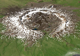
Title : NASA Radar Gives Fresh Look at Alaska Unique Terra
Caption :
A NASA mission to study Alaska unique terrain is providing scientists with their first detailed look at the changing topography of one of Earth most active volcanic regions.Researchers have created a high-resolution digital elevation model of Umnak Island, home to the Okmok Volcano. This model can be used to produce new, accurate geologic maps. The most recent topographic map of the region was made in 1957 from aerial photographs. Okmok has erupted four times since then, dramatically changing the landscape.The Alaska scientists used data gathered in October 2000 by the AirSAR instrument, which was designed, built and operated by NASA. AirSAR is a side-looking imaging radar system carried aboard a NASA DC-8. It collected the Alaska data as part of its PacRim 2000 Mission, which took the instrument to French Polynesia, American and Western Samoa, Fiji, New Zealand, Australia, New Guinea, Indonesia, Malaysia, Cambodia, Philippines, Taiwan, South Korea, Japan, Northern Marianas, Guam, Palau, Hawaii and Alaska.
|
|

